This is about how we measure the position on the surface of the earth, or possibly another planet.
The most common system is latitude and longitude:
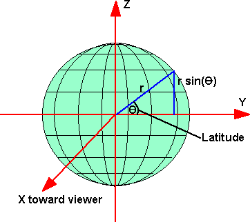
- Latitude - an angle which is +90 degrees at the north pole, 0 degrees at the equator and -90 degrees at the south pole.
- Longitude - an angle about the line between the north and south poles, with 0 degrees at the Greenwich meridian.
However, since the earth is not a perfect sphere there is a need for more complex systems. Modifications to latitude and longitude discussed here.
Spatial Reference Frames
So far we have two possible ways to specify the position of a point on the earths surface. The Latitude/Longitude is an example of a Geodetic spatial reference frame. The x,y,z coordinates of a Geocentric spatial reference frame.
There is a third possible method which involves projecting the earths surface onto another shape such as a cylinder, for example, UTM (Universal Transverse Mercator).
| Code | Name |
| GD (optional synonym GDC) | Geodetic spatial reference frame |
| GC (optional synonym GCC) | Geocentric spatial reference frame |
| UTM | Universal Transverse Mercator |
Aerospace Standards
Thank you very much to Noel Hughes who sent me the following information:
There is no "global reference" coordinate frame.
The closest to this is ECI - Earth Centered Inertial. In the space craft world, this frame has the Z axis along the Earth rotation axis, the X axis along the Vernal equinox - the line of equinox's the intersection of the Earth equatorial plane and the plane of the Earth orbit ecliptic.
The obliquity - the angle between the equatorial and ecliptic planes - remains approximately constant ~23 1/2 degrees, but the Earth rotation axis, and thus, the line of equinoxes, rotates around the normal to the ecliptic through 360 degrees every, roughly, 26000 years - about 50 arc seconds per year. (I knew 26 was in there somewhere). For high accuracy attitude work, you have to specify the epoch (the time) of the ECI coordinate frame you're using. There are several standard , 1950, 1984 and 1/01/2000.
That having been said, there is an infinite number of coordinate frames; coordinate frame confusion is an on going problem. ECEF - Earth Centered, Earth Fixed has the z axis aligned with ECI but the X axis goes through the Prime Meridian, thus this frame rotates with the Earth. The Missile Defense Agency defines ECI as aligned with ECEF at a particular time and inertially fixed thereafter. Every piece of aerospace hardware will have a coordinate frame attached to it; ALWAYS KNOW WHAT COORDINATE FRAME(S) YOU ARE WORKING IN.